 Open Data Science Europe Metadata Catalog
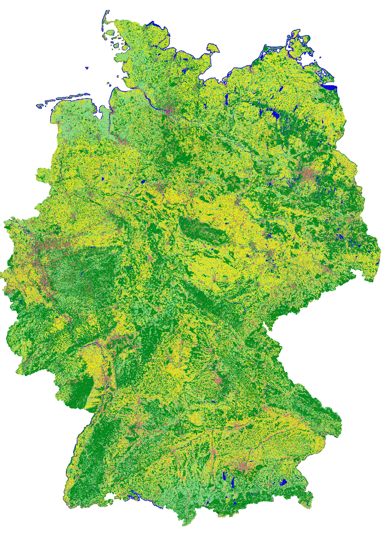
Landcover classification map of Germany 2021 based on Sentinel-2 data
This landcover map was produced with a classification method developed in the project incora (Inwertsetzung von Copernicus-Daten für die Raumbeobachtung, mFUND Förderkennzeichen: 19F2079C) in cooperation with ILS (Institut für Landes- und Stadtentwicklungsforschung gGmbH) and BBSR (Bundesinstitut für Bau-, Stadt- und Raumforschung) funded by BMVI (Federal Ministry of Transport and Digital Infrastructure). The goal of incora is an analysis of settlement and infrastructure dynamics in Germany based on Copernicus Sentinel data. Even though the project is concluded, the annual land cover classification product is continuously generated.
This classification is based on a time-series of monthly averaged, atmospherically corrected Sentinel-2 tiles (MAJA L3A-WASP: https://geoservice.dlr.de/web/maps/sentinel2:l3a:wasp; DLR (2019): Sentinel-2 MSI - Level 2A (MAJA-Tiles)- Germany). It consists of the following landcover classes:
10: forest
20: low vegetation
30: water
40: built-up
50: bare soil
60: agriculture
Potential training and validation areas were automatically extracted using spectral indices and their temporal variability from the Sentinel-2 data itself as well as the following auxiliary datasets:
- OpenStreetMap (Map data copyrighted OpenStreetMap contributors and available from htttps://www.openstreetmap.org)
- Copernicus HRL Imperviousness Status Map 2018 (© European Union, Copernicus Land Monitoring Service 2018, European Environment Agency (EEA))
- S2GLC Land Cover Map of Europe 2017 (Malinowski et al. 2020: Automated Production of Land Cover/Use Map of Europe Based on Sentinel-2 Imagery. Remote Sens. 2020, 12(21), 3523; https://doi.org/10.3390/rs12213523 )
- Germany NUTS administrative areas 1:250000 (© GeoBasis-DE / BKG 2020 / dl-de/by-2-0 / https://gdz.bkg.bund.de/index.php/default/nuts-gebiete-1-250-000-stand-31-12-nuts250-31-12.html )
- Contains modified Copernicus Sentinel data (2020), processed by mundialis
Processing was performed for blocks of federal states and individual maps were mosaicked afterwards.
For each class 100,000 pixels from the potential training areas were extracted as training data.
An exemplary validation of the classification results was perfomed for the federal state of North Rhine-Westphalia as its open data policy allows for direct access to official data to be used as reference. Rules to convert relevant ATKIS Basis-DLM object classes to the incora nomenclature were defined. Subsequently, 5.000 reference points were randomly sampled and their classification in each case visually examined and, if necessary, revised to obtain a robust reference data set. The comparison of this reference data set with the incora classification yielded the following results:
overall accuracy: 83.5%
class: user's accuracy / producer's accuracy (number of reference points n)
forest: 90.6% / 91.9% (1410)
low vegetation: 69.2% / 82.8% (844)
water: 97.0% / 94.2% (69)
built-up: 96.5% / 97.4% (983)
bare soil: 8.5% / 68.3% (41)
agriculture: 96.6% / 68.4% (1653)
Compared to the previous years, the overall accuracy and accuracies of some classes is reduced. 2021 was a rather cloudy year in Germany, which means that the detection of agricultural areas is hampered as it is based on the variance of the NDVI throughout the year. With fewer cloud-free images available, the NDVI variance is not fully covered and as no adaptations have been applied to the algorithm, agricultural fields may get classified as low vegetation or bare soil more often.
Another reason for lower classification accuracy is the significant damage that occured to forest areas due to storm and bark beetle. The validation dataset was generated based on aerial imagery from the years 2018/2019 which and is slowly becoming obsolete. An up-to-date validation dataset will be applied.
Incora report with details on methods and results: pending
Simple
- Date ( Publication )
- 2021-04-22
- Identifier
- dataset
- Status
- On going
- Maintenance and update frequency
- Irregular
- Keywords ( Theme )
-
- Sentinel-2
- Classification
- Land Cover
- mFUND
- MAJA
- Infrastuktur
- Umwelt
- Regionen und Städte
- mfund-projekt:incora
- mfund-fkz:19F2079C
- incora
- Keywords ( Place )
-
- Germany
- GEMET - INSPIRE themes, version 1.0 ( Theme )
-
- Land cover
- Land use
- Use limitation
- None
- Access constraints
- Other restrictions
- Use constraints
- License
- Other constraints
- no limitations to public access
- Other constraints
- Data licence Germany - attribution - version 2.0 or later (DL-DE->BY-2.0) | Datenlizenz Deutschland - Namensnennung - Version 2.0 oder neuer
- Other constraints
- { "id": "dl-by-de/2.0", "name": "Datenlizenz Deutschland Namensnennung 2.0", "url": "https://www.govdata.de/dl-de/by-2-0", "quelle": "Source: mundialis GmbH & Co. KG" }
- Aggregate Datasetindentifier
-
36512b46-f3aa-4aa4-8281-7584ec46c813
- Association Type
- Cross reference
- Aggregate Datasetindentifier
- db130a09-fc2e-421d-95e2-1575e7c4b45c
- Association Type
- Cross reference
- Aggregate Datasetindentifier
- ad2646e3-5667-40bd-b80b-73151949747c
- Association Type
- Cross reference
- Aggregate Datasetindentifier
- 9246503f-6adf-460b-a31e-73a649182d07
- Association Type
- Cross reference
- Spatial representation type
- Grid
- Distance
- 10 meters
- Metadata language
- en
- Character set
- UTF8
- Topic category
-
- Geoscientific information
- Description
- Germany
- Begin date
- 2021-01-01
- End date
- 2021-12-31
))
- Reference system identifier
- EPSG:32632 (UTM 32N)
- Distribution format
-
-
GeoTIFF
(
1.0
)
-
GeoTIFF
(
1.0
)
- OnLine resource
- https://data.mundialis.de/geodata/lulc-germany/classification_2021/classification_map_germany_2021_v01_COG.tif ( WWW:DOWNLOAD-1.0-http--download )
- OnLine resource
- https://data.mundialis.de/geodata/lulc-germany/classification_2021/LICENSE.html ( WWW:DOWNLOAD-1.0-http--download )
- Hierarchy level
- Dataset
Conformance result
- Date ( Publication )
- 2010-12-08
- Other citation details
- http://data.europa.eu/eli/reg/2010/1089/2014-12-31
- Explanation
- See specified reference
- Pass
- Yes
- Statement
- derived from Sentinel-2 MSI - Level 3A-WASP
gmd:MD_Metadata
- File identifier
- d401d629-94d7-4b2c-927f-eec54948698f XML
- Metadata language
- en
- Character set
- UTF8
- Hierarchy level
- Dataset
- Date stamp
- 2023-02-28T10:32:54
- Metadata standard name
- ISO 19115:2003/19139
- Metadata standard version
- 1.0
Citation proposal
(2021) . Landcover classification map of Germany 2021 based on Sentinel-2 data.
https://data.opendatascience.eu/geonetwork/srv/api/records/d401d629-94d7-4b2c-927f-eec54948698f
Overviews
Provided by
