Open Data Science Europe Metadata Catalog
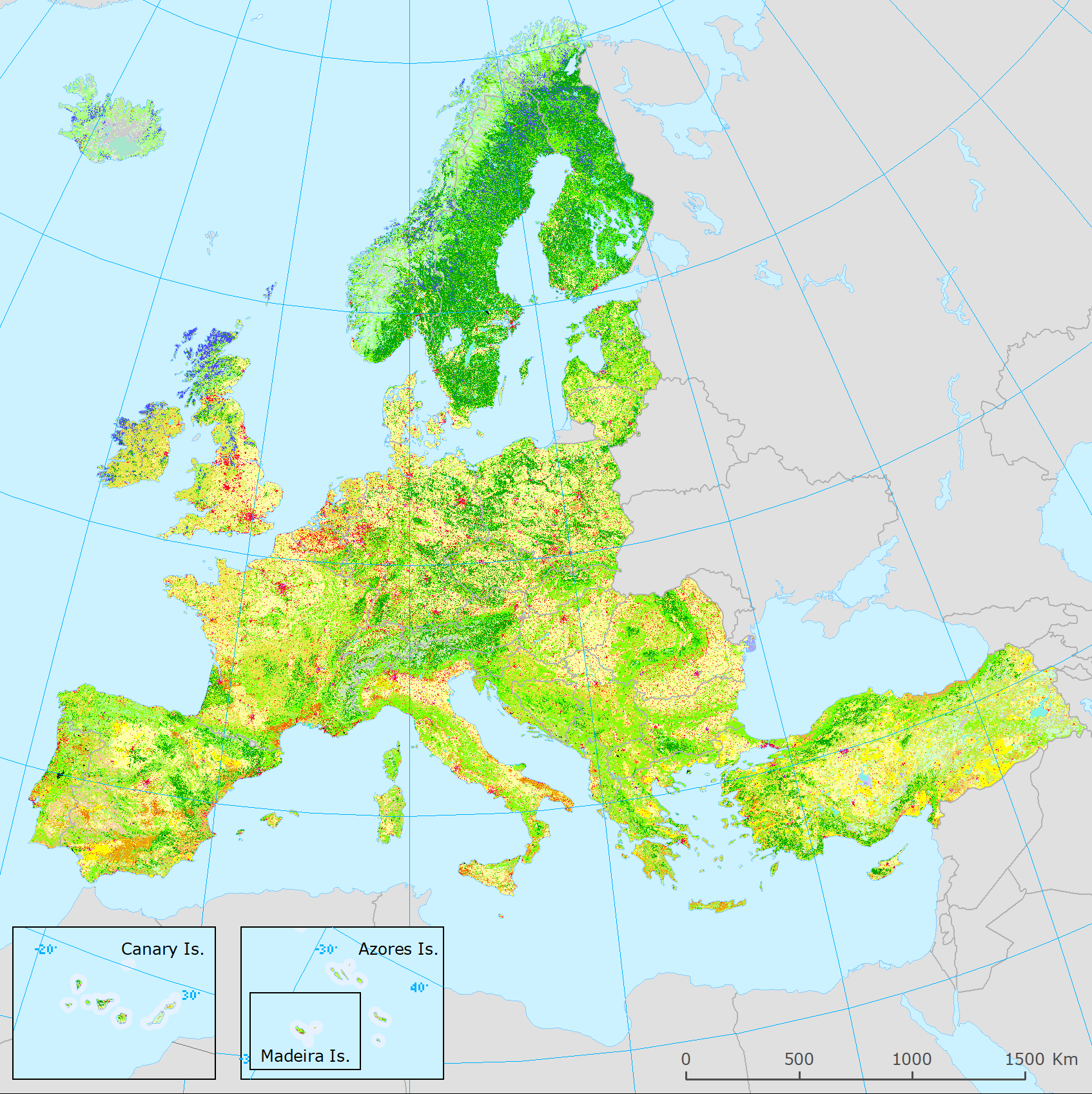
Corine Land Cover 2018 (raster 100m) version 20 accounting layer, Jun. 2019
The present 100m raster dataset is the 2018 CLC status layer modified for the purpose of consistent statistical analysis in the land cover change accounting system at EEA.
CORINE Land Cover (CLC) data are produced from 1986 for European (EEA member or cooperating) countries. Altogether five mapping inventories were implemented in this period, producing five status layers (CLC1990, CLC2000, CLC2006, CLC2012, CLC2018) and four CLC-Change (CLCC) layers for the corresponding periods (1990-2000, 2000-2006, 2006-2012, 2012-2018). Pan-European CLC and CLCC data are available as vector and raster products.
Due to the technical characteristics of CLC and CLCC data, the evolution in CLC update methodology and in quality of input data, time-series statistics derived directly from historical CLC data includes several inconsistencies. In order to create a statistically solid basis for CLC-based time series analysis, a harmonization methodology was elaborated.
Simple
- Date ( Creation )
- 2019-06-11
- Date ( Publication )
- 2019-07-23
- Edition
- 01.00
- Identifier
- eea_r_3035_100_m_clc-2018-acc_p_2017-2018_v01_r00
- Maintenance and update frequency
- As needed
- GEMET - INSPIRE themes, version 1.0 ( Theme )
-
- Land cover
- Land use
- Keywords
-
- Keywords
-
- GEMET ( Theme )
-
- accounting
- land use
- land cover
- Continents, countries, sea regions of the world. ( Place )
-
- EEA39
- Spatial scope ( Theme )
- INSPIRE ( Theme )
-
- INSPIRE
- Use limitation
- EEA standard re-use policy: unless otherwise indicated, re-use of content on the EEA website for commercial or non-commercial purposes is permitted free of charge, provided that the source is acknowledged (http://www.eea.europa.eu/legal/copyright). Copyright holder: European Environment Agency (EEA).
- Access constraints
- Other restrictions
- Other constraints
- No limitations to public access
- Spatial representation type
- Grid
- Distance
- 100 m
- Metadata language
- en
- Topic category
-
- Imagery base maps earth cover
- Geoscientific information
))
- Begin date
- 2017-01-01
- End date
- 2018-12-31
- Unique resource identifier
- EPSG:3035
- Distribution format
-
-
GTiff
(
1
)
-
GTiff
(
1
)
- OnLine resource
- https://www.eea.europa.eu/data-and-maps/data/corine-land-cover-accounting-layers ( WWW:LINK-1.0-http--link )
- OnLine resource
- https://land.discomap.eea.europa.eu/arcgis/rest/services/Land/CLC_accounting_layer_2018/ImageServer ( ESRI:REST )
- OnLine resource
-
0
(
OGC:WMS
)
CLC_accounting_layer_2018
- OnLine resource
- Direct download ( WWW:URL )
OnLine resource
- Hierarchy level
- Dataset
Conformance result
- Date ( Publication )
- 2010-12-08
- Explanation
- See the referenced specification
- Statement
-
The Corine Land Cover (CLC) is a European programme, coordinated by the European Environment Agency (EEA), providing consistent information on land cover and land cover changes across Europe. CLC products are based on (visual or semi-automated) interpretation of high-resolution multispectral satellite imagery by the national teams of the participating countries - the EEA member or cooperating countries. Besides the original and still dominating Computer Assisted Photo-Interpretation (CAPI) methodology, the number of countries applying more advanced (bottom-up) solutions is increasing.
National teams provided vector CLC datasets within the CLC1990, CLC2000 CLC2006, CLC2012 and CLC2018 projects. All features in the vector databases are classified into the standardized hierarchical 3-level CLC nomenclature, which includes 44 classes optimized for pan-European mapping. CLC status layers are characterized with 25 ha Minimum Mapping Unit (MMU) and 100m Minimum Mapping Width (MMW), while the applied MMU for CLC change layers is 5 ha. CLC change polygons are created directly, based on visual comparison and interpretation of satellite images from the two corresponding dates. Update of CLC status layers is done by adding CLC-Change layer to the previous CLC status layer. The resulting national land cover inventories are integrated into a seamless land cover map of Europe. As a next step, all seamless vector layers are rasterized to the 100m resolution grid with the CELL_CENTER method.
The creation of the CLC accounting layers:
The solution applied for the harmonization of CLC time-series is based on the idea to combine CLC status and change information in order to create a homogenous quality time series of CLC / CLC-Change layers for land cover accounting purposes fulfilling the relation: CLC-Change = Accounting CLC_ new status – Accounting CLC old status. As a consequence of this criteria, CLC changes for longer period (e.g. 2000-2018) may be derived from the differences of the corresponding CLC accounting status layers accordingly.
The CLC accounting methodology is characterized by two major steps:
I. Add more detail to the latest CLC status layer (CLC2018) from previous CLCC information and use this modified layer (CLC2018 accounting layer) as a reference,
II. Create previous CLC (accounting) status layers by "backdating" of the reference, realized by subtracting CLCC-based information from CLC2018 accounting layer.
Based on the above principles, the working steps of the creation of CLC accounting layers are as follows:
(1) Include formation information from the CLC-Change layers into the CLC2018 status layer, thereby creating the CLC2018 accounting layer, as follows:
(1a) Overwrite CLC2018 with formation code from CLC-Change 2000-2006. Intermediate result: A1_CLC2018,
(1b) Overwrite A1_CLC2018 with formation code from CLC-Change 2006-2012. Intermediate result: A2_CLC2018
(1c) Overwrite A2_CLC2018 with formation code from CLC-Change 2012-2018. Result: Final accounting layer for the reference year 2018 (the present layer).
(2) Create CLC2012 accounting layer by including consumption information into CLC2018ACC_V2018_20.tif from CLC-Change 2012-2018. Result: Final accounting layer for the reference year 2012.
(3) Create CLC2006 accounting layer by including consumption information into CLC2012ACC_V2018_20.tif from CLC-Change 2006-2012. Result: Final accounting layer for the reference year 2006.
(4) Create CLC2000 accounting layer by including consumption information into CLC2006ACC_V2018_20.tif from CLC-Change 2000-2006. Result: Final accounting layer for the reference year 2000.
The harmonization was carried out on the version V2018_20 of Corine Land Cover European database (RELEASE V2018_20; dated 06/2019).
Notes
The simple solution applied for the combination of CLC and CLCC layers causes some known issues, such as:
(1) Modified CLC layers lose statistical comparability with original CLC layers, because of increased geometry - smaller than 25ha MMU features will appear locally where changes appear.
(2) “Fake features” may appear in the backdated CLC status layers due to inconsistencies between CLC-Change datasets and due to omitted (not interpreted) changes
In the frame of ETC-ULS activity a raster generalization methodology was developed to eliminate fake features and attenuate effects of mixed MMU (https://forum.eionet.europa.eu/etc-urban-land-and-soil-systems/library/5.-copernicus-rfs16_006-sc-56586/7-task-7-clc-adjusted-layers-clc-cube-be-revised). This methodology has not been approved yet, so not applied to actual CLC accounting layers.
gmd:MD_Metadata
- File identifier
- 5a5f43ca-1447-4ed0-b0a6-4bd2e17e4f4d XML
- Metadata language
- en
- Character set
- UTF8
- Hierarchy level
- Dataset
- Date stamp
- 2021-11-08T18:45:39
- Metadata standard name
- ISO 19115/19139
- Metadata standard version
- 1.0
Citation proposal
European Environment Agency) (2019) . Corine Land Cover 2018 (raster 100m) version 20 accounting layer, Jun. 2019.
https://data.opendatascience.eu/geonetwork/srv/api/records/5a5f43ca-1447-4ed0-b0a6-4bd2e17e4f4d
Overviews
Provided by