 Open Data Science Europe Metadata Catalog
continual
Type of resources
Available actions
Topics
Keywords
Contact for the resource
Provided by
Years
Formats
Representation types
Update frequencies
Resolution
-

Orthophotos are high-resolution, distortion-free, true-to-scale images of the earth's surface. They are produced by photogrammetric methods with the use of orientation parameters and of a digital terrain model from aerial photographs that are available as vertical images. Digital orthophotos are georeferenced. They are available for the entire area of NRW and are renewed in a 3-year cycle. They are produced according to the product standard of the Federal State, which is based on the specifications of an AdV standard (AdV (german): Arbeitsgemeinschaft der Vermessungsverwaltungen der Länder) and have a ground resolution of 10cm/pixel. They are 4-band multispectral images with a band assignment of RGBI (Red-Green-Blue-Near Infrared).
-
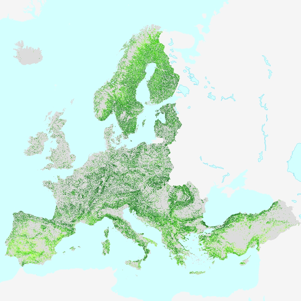
This metadata refers to the HRL Forest 2018 primary status layer Tree Cover Density (TCD). The TCD raster product provides information on the proportional crown coverage per pixel at 10m spatial resolution and ranges from 0% (all non-tree covered areas) to 100%, whereby Tree Cover Density is defined as the "vertical projection of tree crowns to a horizontal earth’s surface“. The production of the High Resolution Forest layers was coordinated by the European Environment Agency (EEA) in the frame of the EU Copernicus programme. The HRL Forest product consists of 3 types of (status) products and additional change products. The status products are available for 2012, 2015, and 2018 reference years: 1. Tree cover density (TCD) (level of tree cover density in a range from 0-100%) 2. Dominant leaf type (DLT) (broadleaved or coniferous majority) 3. Forest type product (FTY). The forest type product allows to get as close as possible to the FAO forest definition. In its original (10m (2018) / 20m (2012, 2015)) resolution it consists of two products: a dominant leaf type product that has a MMU of 0.5 ha, as well as a 10% tree cover density threshold applied, and 2) a support layer that maps (now only available on demand), based on the dominant leaf type product, trees under agricultural use and in urban context (derived from CLC and imperviousness 2009 data). For the final 100 m product trees under agricultural use and urban context from the support layer are removed. NEW for 2018: the 10m 2018 reference year FTY product now also has the agricultural/urban trees removed. In the past this was done only for the 100m product, now it is consistently applied for both the 10m and the 100m FTY products. This dataset is provided as 10 meter rasters (fully conformant with the EEA reference grid) in 100 x 100 km tiles grouped according to the EEA38 countries and the United Kingdom.