 Open Data Science Europe Metadata Catalog
imageryBaseMapsEarthCover
Type of resources
Available actions
Topics
Keywords
Contact for the resource
Provided by
Years
Formats
Representation types
Update frequencies
status
Resolution
-

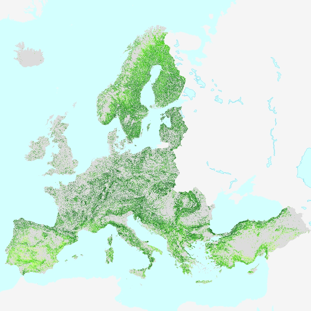
The Land Cover Map of Europe 2017 is a product resulting from the Phase 2 of the S2GLC project. The final map has been produced on the CREODIAS platform with algorithms and software developed by CBK PAN. Classification of over 15 000 Sentinel-2 images required high level of automation that was assured by the developed software. The legend of the resulting Land Cover Map of Europe 2017 consists of 13 land cover classes. The pixel size of the map equals 10 m, which corresponds to the highest spatial resolution of Sentinel-2 imagery. Its overall accuracy was estimated to be at the level of 86% using approximately 52 000 validation samples distributed across Europe. Related publication: https://doi.org/10.3390/rs12213523
-
This metadata refers to the HRL Forest 2018 primary status layer Tree Cover Density (TCD). The TCD raster product provides information on the proportional crown coverage per pixel at 10m spatial resolution and ranges from 0% (all non-tree covered areas) to 100%, whereby Tree Cover Density is defined as the "vertical projection of tree crowns to a horizontal earth’s surface“. The production of the High Resolution Forest layers was coordinated by the European Environment Agency (EEA) in the frame of the EU Copernicus programme. The HRL Forest product consists of 3 types of (status) products and additional change products. The status products are available for 2012, 2015, and 2018 reference years: 1. Tree cover density (TCD) (level of tree cover density in a range from 0-100%) 2. Dominant leaf type (DLT) (broadleaved or coniferous majority) 3. Forest type product (FTY). The forest type product allows to get as close as possible to the FAO forest definition. In its original (10m (2018) / 20m (2012, 2015)) resolution it consists of two products: a dominant leaf type product that has a MMU of 0.5 ha, as well as a 10% tree cover density threshold applied, and 2) a support layer that maps (now only available on demand), based on the dominant leaf type product, trees under agricultural use and in urban context (derived from CLC and imperviousness 2009 data). For the final 100 m product trees under agricultural use and urban context from the support layer are removed. NEW for 2018: the 10m 2018 reference year FTY product now also has the agricultural/urban trees removed. In the past this was done only for the 100m product, now it is consistently applied for both the 10m and the 100m FTY products. This dataset is provided as 10 meter rasters (fully conformant with the EEA reference grid) in 100 x 100 km tiles grouped according to the EEA38 countries and the United Kingdom.
-

Orthophotos are high-resolution, distortion-free, true-to-scale images of the earth's surface. They are produced by photogrammetric methods with the use of orientation parameters and of a digital terrain model from aerial photographs that are available as vertical images. Digital orthophotos are georeferenced. They are available for the entire area of NRW and are renewed in a 3-year cycle. They are produced according to the product standard of the Federal State, which is based on the specifications of an AdV standard (AdV (german): Arbeitsgemeinschaft der Vermessungsverwaltungen der Länder) and have a ground resolution of 10cm/pixel. They are 4-band multispectral images with a band assignment of RGBI (Red-Green-Blue-Near Infrared).
-

The Earth Observations Group (EOG) is producing a version 1 suite of average radiance composite images using nighttime data from the Visible Infrared Imaging Radiometer Suite (VIIRS) Day/Night Band (DNB). Prior to averaging, the DNB data is filtered to exclude data impacted by stray light, lightning, lunar illumination, and cloud-cover. Cloud-cover is determined using the VIIRS Cloud Mask product (VCM). In addition, data near the edges of the swath are not included in the composites (aggregation zones 29-32). Temporal averaging is done on a monthly and annual basis. The version 1 series of monthly composites has not been filtered to screen out lights from aurora, fires, boats, and other temporal lights. However, the annual composites have layers with additional separation, removing temporal lights and background (non-light) values. The version 1 products span the globe from 75N latitude to 65S. The products are produced in 15 arc-second geographic grids and are made available in geotiff format as a set of 6 tiles. The tiles are cut at the equator and each span 120 degrees of latitude. Each tile is actually a set of images containing average radiance values and numbers of available observations. In the monthly composites, there are many areas of the globe where it is impossible to get good quality data coverage for that month. This can be due to cloud-cover, especially in the tropical regions, or due to solar illumination, as happens toward the poles in their respective summer months. Therefore, it is imperative that users of these data utilize the cloud-free observations file and not assume a value of zero in the average radiance image means that no lights were observed. The version 1 monthly series is run globally using two different configurations. The first excludes any data impacted by stray light. The second includes these data if the radiance vales have undergone the stray-light correction procedure (Reference). These two configurations are denoted in the filenames as "vcm" and "vcmsl" respectively. The "vcmsl" version, that includes the stray-light corrected data, will have more data coverage toward the poles, but will be of reduced quality. It is up to the users to determine which set is best for their applications. The annual versions are only made with the “vcm” version, excluding any data impacted by stray light. Filenaming convention: The version 1 composite products have 7 filename fields that are separated by an underscore "_". Internal to each field there can be an additional dash separator "-". These fields are followed by a filename extension. The fields are described below using this example filename: SVDNB_npp_20140501-20140531_global_vcmcfg_v10_c201502061154.avg_rade9 Field 1: VIIRS SDR or Product that made the composite "SVDNB" Field 2: satellite name "npp" Field 3: date range "20140501-20140531" Field 4: ROI "global" Field 5: config shortname "vcmcfg" Field 6: version "v10" is version 1.0 Field 7: creation date/time Extension: avg_rade9 The annual products can have other values for the config shortname (Field 5). They are: "vcm-orm" (VIIRS Cloud Mask - Outlier Removed) This product contains cloud-free average radiance values that have undergone an outlier removal process to filter out fires and other ephemeral lights. "vcm-orm-ntl" (VIIRS Cloud Mask - Outlier Removed - Nighttime Lights) This product contains the "vcm-orm" average, with background (non-lights) set to zero. "vcm-ntl" (VIIRS Cloud Mask - Nighttime Lights) This product contains the "vcm" average, with background (non-lights) set to zero. Data types/formats: To reach the widest community of users, files are delivered in compressed tarballs, each containing a set of 2 geotiffs. Files with extensions "avg_rade9" contain floating point radiance values with units in nanoWatts/cm2/sr. Note that the original DNB radiance values have been multiplied by 1E9. This was done to alleviate issues some software packages were having with the very small numbers in the original units. Files with extension "cf_cvg" are integer counts of the number of cloud-free coverages, or observations, that went in to constructing the average radiance image. Files with extension “cvg” are integer counts of the number of coverages or total observations available (regardless of cloud-cover). Credit: When using the data please credit the product generation to the Earth Observation Group, Payne Institute for Public Policy.
-
The present 100m raster dataset is the 2018 CLC status layer modified for the purpose of consistent statistical analysis in the land cover change accounting system at EEA. CORINE Land Cover (CLC) data are produced from 1986 for European (EEA member or cooperating) countries. Altogether five mapping inventories were implemented in this period, producing five status layers (CLC1990, CLC2000, CLC2006, CLC2012, CLC2018) and four CLC-Change (CLCC) layers for the corresponding periods (1990-2000, 2000-2006, 2006-2012, 2012-2018). Pan-European CLC and CLCC data are available as vector and raster products. Due to the technical characteristics of CLC and CLCC data, the evolution in CLC update methodology and in quality of input data, time-series statistics derived directly from historical CLC data includes several inconsistencies. In order to create a statistically solid basis for CLC-based time series analysis, a harmonization methodology was elaborated.